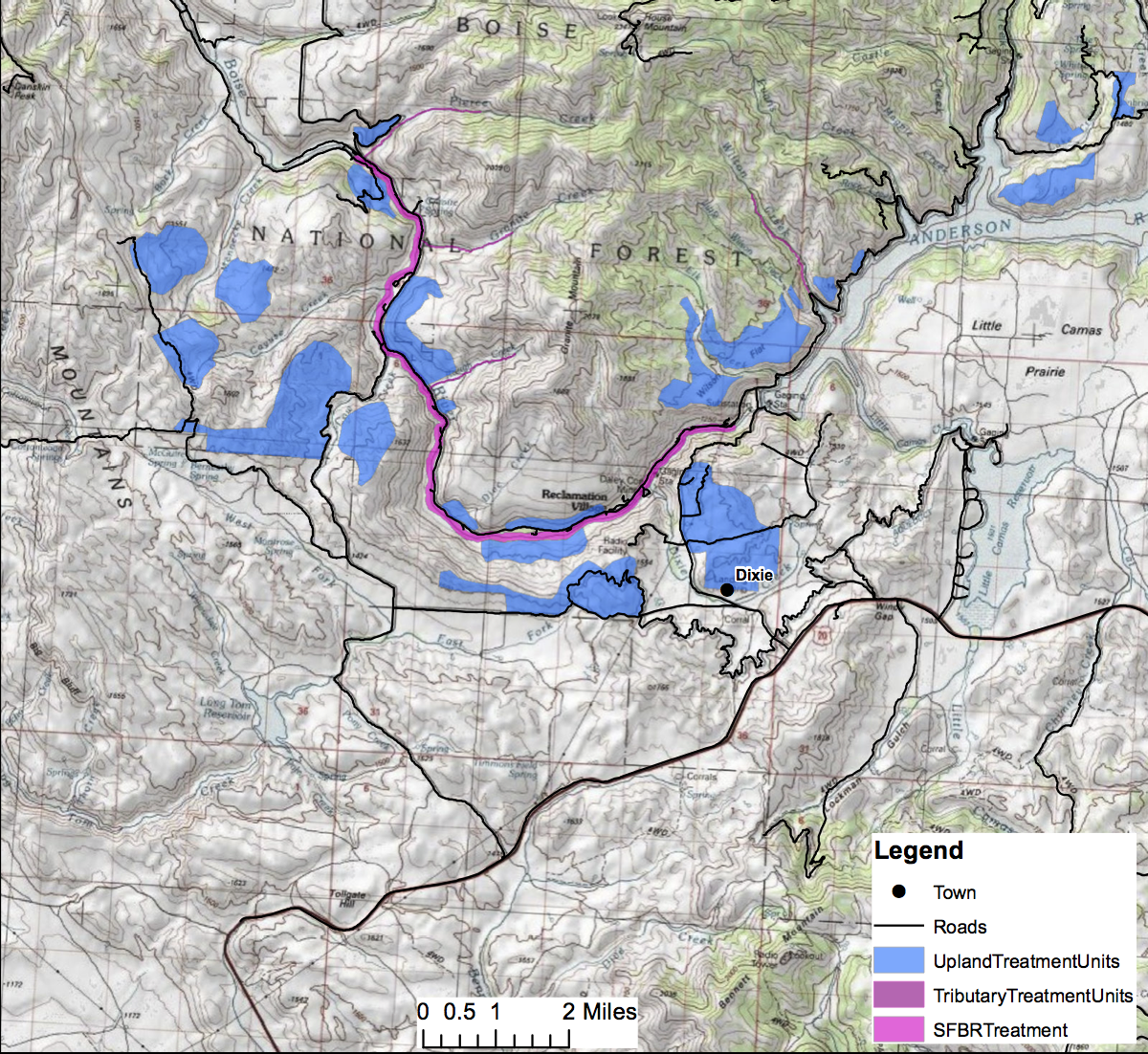
Map of recovery project area. Click on it to enlarge.
The Boise National Forest’s Mountain Home Ranger District asked for public comment on a scoping document on proposed post-wildfire recovery of the South Fork Boise River area. Within a 50,000 acre analysis area the Forest proposes to plant some 7,000 acres of upland areas and 1,500 acres of riparian areas.
Comments were accepted from February 7 to March 7, 2014. The Forest received comments from the Boise Valley Fly Fishers (.pdf) and from the Ted Trueblood Chapter of Trout Unlimited (.pdf) among others. The Forest will complete the recovery plan in 2014 with the goal of significant planting efforts beginning in 2015. Comments from Trout Unlimited pointed out that in 2014 it would be possible to collect seed from cottonwood trees in the summer, and begin to grow new trees from locally-sourced seeds. TU and the Boise National Forest’s Lucky Peak Nursery pioneered this practice since 2011. And in the fall 2014 it should be possible to put willow cuttings along riparian areas where needed, assuming appropriate sources of willow can be found.
If you are interested in following this recovery project you can provide your email to the Boise National Forest here.
Open areas include the South Fork Boise River, downstream from the Anderson Ranch Dam.Recreation along the river corridor is open to day use only, and overnight use is prohibited.Floaters are advised that the river has substantially changed with new channels, flows and large trees in the river.
The Federal government shutdown that started October 1 has thwarted any movement towards long-term recovery of the South Fork Boise River. And any decisions about opening the river or a portion thereof to fishing has also been stymied.
While so-called “essential” staff are still on the job (without pay), which includes fire, law enforcement and burned area emergency rehabilitation activities, other Federal government professionals are not.
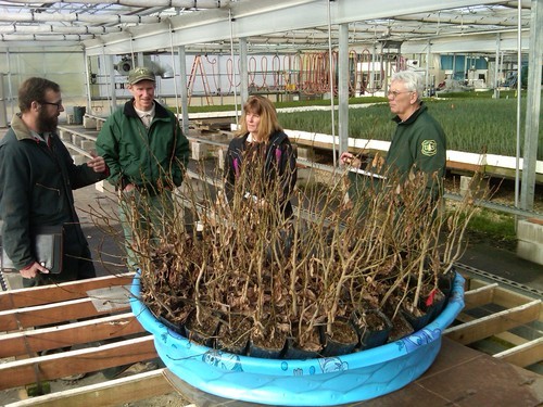
Deep-rooted cottonwoods like those in the tub at Lucky Peak Nursery are available for planting. L to R: Matt Perkins, City of Boise nursery; John Sloan, Lucky Peak Nursery; Pam Harrington, Trout Unlimited; Clark Fleege, Lucky Peak Nursery
Discussions in late September identified the potential for planting cottonwoods in some areas along the South Fork Boise River. Cottonwood cuttings taken from South Fork Boise River have been growing at the Boise National Forest Lucky Peak Nursery, and several dozen of these trees could go in the ground before the snow flies to begin the long-term recovery effort for the South Fork. The meeting to decide when, where and what to plant would have happened October 1st or 2nd, but the government shutdown slammed the door on this little initiative.
Conservation groups had approached the Boise National Forest about the idea to do some planting along the South Fork. The Forest is very interested in using some volunteers and have identified some areas where planting can do some good, and where it would be safe to have volunteers do some work. Not only that, the cottonwood trees are at Lucky Peak Nursery, ready to be put in the ground. But until the government shutdown is over little can be done about it.
Granite Creek blowout washed away the hill side. Perhaps a good location for some cottonwood trees?
Once the shutdown is over and some progress gets made on a planting project we will provide an update at this website.
We grabbed a few charts at the end of Water Year 2013 to put some perspective on the water situation.
Flows from Anderson Ranch Dam:
Flow From Anderson Ranch Dam where blue line = 2013, green line = 2012, red line = long-term average
The summertime flows were 1,600 cfs instead of 1,800 cfs in 2012. The 1,600 cfs flows extended well into August to provide irrigation water to users in the Treasure Valley. The rest of the system was draining so more water was moved from Anderson Ranch pool. And you can see what happened in the reservoir here:
Water stored in Anderson Ranch Dam blue line is 2013 and green line 2012 and long term average is the red line
Anderson Ranch reservoir started the water year (October 2012) very near the average for water in the pool. The low snowpack in the winter meant less runoff into the pool in the spring and early summer. The peak amount of water in May was nowhere near the average, let alone filling Anderson Ranch. The the 1,600 cfs flows pulled the contents to an amount well below average and at a high rate until mid August. The water year ends with 100,000 acre feet in the pool.
The reservoir drained very quickly because it was a year where much less water flowed into Anderson Ranch Reservoir as seen in the chart for the water gage at Featherville:
Water flows on South Fork at Featherville gage with 2013 in blue, 2012 in green and average in red
So the blue line in the chart above shows just how below average the flows were upstream of Anderson Ranch pool. By the way, the spike in river flows in late April 2012 on the green line is a same time when a record flow was observed in the Middle Fork Boise River at Twin Springs gage. Some readers may recall the late April heavy rains that melted much of the lower to mid elevation snow into the South Fork Boise River.
One indication of the water year ending in a whimper is what happened with the flow gage on the South Fork Boise a mile or so downstream of Anderson Ranch Dam:
River flow data in late September 2013 was affected by the landslides into the South Fork Boise
The slides on September 12, 2013 knocked out the water gages for a few days. They are back running now, but the chart above from September 24 shows only a brief period when it was working that day and no data was charted for previous days. This situation is understandable given that much debris tumbled into the South Fork and it may have directly affected the functioning of the gage or perhaps changed the profile of the channel in the area of the gage making a clean reading of water flows a challenge and thus a need to recalibrate the equipment. The automated system for this gage is working as shown on the USGS gage here.
Looking forward, there have been some inquiries and informal discussion whether it would be possible to shape flows from Anderson Ranch Dam in 2014 to deal with the debris and sediment in the South Fork Boise River to help transport the sediment and allow the river to carve a channel through the massive deposits in the river. For any of this to happen it will require water in Anderson Ranch pool that is not yet there. A winter with above average snow could be very important to developing some alternatives to shape the flow releases, their timing and magnitude, and it will have to happen without adverse effects on downstream water users. But readers may be interested in knowing it is a topic of conversation, or at least was prior to the government shutdown.
With the number of slides that occurred from the rain on September 12 we thought it would be useful to provide a primer on the six slides that have been documented. Many of the photos came from different news sources and government agencies. Not all photos were specifically located so a field recon on Monday aided in getting a sense of what happened last week.
A couple of things first: the road is closed from Highway 20 to the Anderson Ranch Dam and down along the South Fork Boise. The road from Highway 20 to Cow Creek bridge is open, and continues to be open downstream to Prairie and beyond. Upstream of Cow Creek bridge the road is closed (as of September 17). Second, the water is murky in the South Fork not only because of the mud flows and land slides that reached the river, but also because of the turbidity in the water coming out of Anderson Ranch Dam. There is a lot of silt that is in suspension in the reservoir.
Each slide is presented in order starting upstream and working in a downstream direction.
1. Approximately one mile downstream of Anderson Ranch Dam you reach the boat ramp (a.k.a. Tailwaters) and you see the first landslide:
Landslide downstream of boat ramp. Photo from KTVB
Mud and debris plugged the side channel on river right and created a rapid which currently has some snags. Navigation could be a problem until the trees are washed down or removed. The side channel will not return unless higher flows scour the channel. The slide also put enough material in the river to raise the water elevation and create a slow water area, probably a couple of hundred yards in length, upstream of the slide. It is similar to what anglers and boaters have experienced upstream Rough Creek since the landslide in January 1996.
2. Downstream a few hundred feet there is a separate slide that appears to have delivered less volume to the river, but nonetheless put a lot of mud and debris on the road.
Second mudslide is just downstream of the first one. Photo by John Wirt, US Geological Survey
Some anglers refer to this general area as the Owl Rock Hole. The rock outcrop partially obscures the river when the photos are from the road, high above the river.
3. Just east of Reclamation Village a slide covered some 700 feet of road with mud.
Mud slide east of Reclamation Village. Photo from Boise National Forest
Approximately 3,000 cubic yards of material will have to be removed from the road. The photo indicates much more than that crossed the road, much of which entered the South Fork.
The photo below is another angle and shows the Anderson bridge upstream of the slide as well as how far across the river the slide reached.
Mud slide at Reclamation Village puts the squeeze on the River
Some anglers will remember on the south side of the river the large rock outcrop with a deep hole below it. Wherein lurk some large trout. The early report is the deep pool appears to be more of a run than a pool. And the photo does appear to show a some mud across the river at the subsurface.
4. From Reclamation Village it is approximately 4.5 miles downstream to the confluence with Rough Creek. There may be slides between these two points but no identifying photographs have been produced. And the road is closed in this reach so any field recon effort is not possible.
Rough Creek and South Fork Boise River road
At Rough Creek a major slide pushed across the road, covered much of the slide area of 1996 and dropped into the river. It appears the 2013 edition of the Rough Creek slide is different than the 1996 event, at least from the photographs and inspection of other slides. The new one resulted from the rain after fire removed nearly all vegetation in the catchment. There is a lot of sand and silts in the mud, and some coarse material typical of the Idaho batholith. The slide in January 1996 was very different because it had more evidence of a mass failure dominated by large sized rubble and boulders moving into the river.
View looking downstream with Rough Creek slide coming from the right.
The extent of the mud flow versus the water is evident in the above photo. Much of the profile line of the mud flow approximates the slide from 1996. It appears that the amount of debris on this slide was relatively less than at Reclamation Village. The slide area and rapid is a confined river channel thanks to the rubble that remains from 1996 and the water velocities are relatively higher in this area. Even at the 600 cfs flows as in the photo above there is already a demarcation between the river flow and the mud flow.
5. The big debris flow occurred at Granite Creek. We already provided some background on this blowout. If anything, the scale of the event was underestimated.
South Fork Boise River and Granite Creek debris flow. Courtesy USDA Forest Service.
The photo at left shows the debris fan well into the river and then it appears to taper off to river right along a 500 foot length of channel. Secondly, there is significant change to the backwater created by the mudflow as the river banks are flooded and the river much wider. The streamside willows are now nearly in the middle of the river!
What the photo does not show is the extent of the debris that washed downstream around the bend in the river. The Rock Garden is completely covered. The Pine Tree Hole is no more. The hole filled with mud and debris and now has a fast moving riffle cutting through the deposit.
This is where the Rock Garden used to transition into the Pine Tree Hole. Note the large tree on the new gravel bar.
In the photograph above and island could form from the gravel bar if high flows do not move the tree. Vegetation can establish and stabilize the deposit.
For nearly one-half mile – from Granite Creek around the bend – the river takes on a series of S curves, as illustrated in the photo below.
View upstream at what once was the Rock Garden
This new channel is cutting through the mud flow and will continue to change the form of the stream as there is no stream side vegetation to stabilize the banks. And it appears much of the material may be appropriate sized gravel suitable for spawning, assuming the smaller sands and silts can be washed away. Concerns about a lack of spawning habitat in the main river may have been addressed.
Around the bend, downstream of what used to be the Pine Tree Hole
One takeaway from seeing the extent of the mud slide from Granite Creek is that anglers will need to be aware of safety hazards associated with the relatively loose material deposited along the stream bottom as well as the significant amount of trees and associated debris.
One gravel bar made up of material from Granite Creek is nearly one-half mile downstream. The Granite Creek bomb slide event appears to have won the prize for affecting the most area along the river.
6. The final mud flow and slide is at Pierce Creek, and there is some good news here. When the Forest Service initially circulated aerial photos of the mud slides across the road and into the river Pierce Creek was not included. This is because the new bridge at Pierce Creek was designed and built to pass more water under it. And it worked. And because it worked there was little in the photograph to see, at least across the road.
The mud in Pierce Creek went under the bridge.
It appears the slide from Pierce Creek is on the scale with Rough Creek, neither being as large as Granite Creek. But still significant nonetheless.
The bridge was constructed in 2011 as a cooperative project with a number conservation groups and agencies to reconnect Pierce Creek so trout from the South Fork Boise River could access it. A four foot dimeter culvert was replaced with a bridge with a much larger opening that in this instance was able to pass the mud flows and debris into the river.
Much of the grade control structure of Pierce Creek downstream of the bridge was blown out.
One effect from the magnitude and character of the mud flow was its impact on Pierce Creek. Much of the rock placed in the simulated channel was washed out and this will need to be replaced so that fish passage can be restored. The photo above shows the rock on one bank was either scoured away or covered with mud. On the other side of Pierce Creek some of the vegetation appears much less affected. Some very large foundation rocks in the stream bottom held in place as the waterfall is evidence of the loss of a more gradual step pool channel.
So that’s it for where the slides occurred and what they look like. It’s way to early to know what this all means for the South Fork Boise River. Much clean up and repair is occurring. Rehabilitation of the burned areas will commence this fall and mulching and seeding activities will help the land recover and stabilize so these type of events will be less likey to happen in the future.